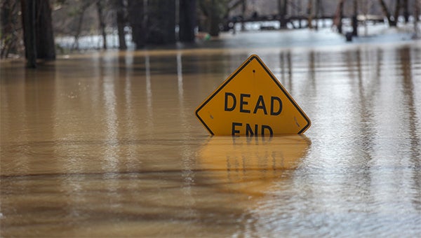
Floodwaters taking a toll
Published 6:56 pm Tuesday, March 13, 2018
The boat had just pulled away from the shore and was entering a deeper channel of the flooded area off Haining Road when Reed Birdsong pointed out the location.
“Long Lake Road is just over there,” he said, pointing toward the northwest as the boat headed toward flooded areas of Ford Subdivision, the Kings community and Chickasaw.
The Mississippi River’s level was 49.55 feet Tuesday afternoon, and is forecast to reach a 50.5-foot crest at Vicksburg by Saturday. Flood stage is 43 feet.
Fifty feet, Warren County Emergency management director John Elfer told the Vicksburg Kiwanis Club Tuesday, “Is a major flood for us; but we’re able to pretty much manage that.”
As the river has risen over the past few weeks, it has elevated the level of the Yazoo River and the Yazoo Diversion Canal, and spread their waters across areas that are usually dry; at this time of year some of that land would be prepared for planting corn or soybeans.
The city’s water wells are surrounded.
Traveling through an area under flood is difficult. The landmarks that would usually guide someone are hidden underwater. Instead, a boater makes their way through a maze of standing and fallen trees, floating logs, utility poles and all manner of debris from floating plastic bottles, to discarded ice chests and derelict boats floating upside down in the water.
Depths vary from 4 to 9 feet as the boat makes its way through the area.
Alligators and turtles sun themselves on fallen logs. Asian carp fly out of the water as vibrations from the boat’s motor force them up.
At Ford Subdivision, water is about halfway up the walls of a home on the ground and laps at the pilings or just under the floors of elevated homes. It covers Williams, Ford and Eva streets all the way to the Kansas City Southern Railroad tracks, which acts as a makeshift levee protecting the eastern side of the tracks.
In other areas, floodwaters lap at the rear yards of homes just out of the flood’s reach like waves on a beach. Some street and stop signs sit just above the waterline, while others are submerged.
Waters almost reach the rear yards of homes on Railroad Alley in the Kings community.
The yards of homes along Chickasaw Lane and Chickasaw Road are underwater and the homes on them have several feet of water inside. One vacant house has water almost up to its roof. Fields that once held corn and soybeans are covered. At one spot, two vent pipes rise above the water, their openings covered with large rocks. In another area, a camper is barely seen above the water.
Elfer puts the amount of land covered by the flood at “thousands of acres,” and said there is another problem area in the county.
He said the Yazoo backwater area, which includes Steele Bayou, is becoming a problem area.
The Steele Bayou Control Structure, which prevents the Mississippi from going into Steele Bayou during flood, is closed, causing flooding in the backwater area, Elfer said.
“The Mississippi Delta drains through that structure,” he said. “The problem is when the river gets above those locks, the water doesn’t flow freely any more. And all that water is backing up into an area that I have not seen flood since I have been here 21 years,” Elfer said. “It’s a major, major problem.”
He said working with the Corps of Engineers Vicksburg District and with local, state and federal agencies, “We’ve been able to get some pumps, we’ve filled 42,000 sandbags, and we’ve got a major flood fight going on in the Eagle Lake community.”
Elfer said county officials have daily briefings on the flooding, and have weekly meetings with the Mississippi Emergency Management Agency.
“Everybody’s communicating; it’s one of the more efficiently run flood events that I’ve ever been in, and I think, unfortunately, it’s because we’ve got a lot to do and we work with the same people all the time.”


