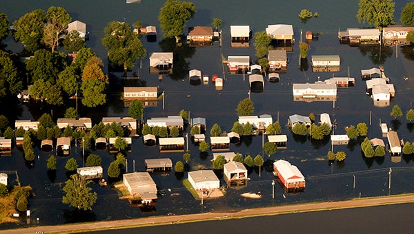
Forecasts call for higher crest in backwater
Published 6:56 pm Tuesday, June 4, 2019

- Homes in Eagle Lake are inundated by floodwaters in these aerial photographs captured Monday. Weather forecasts call for 3-to-6 inches of rain to fall in the area between late Wednesday and the weekend, likely raising the level of floodwaters in the area. (Walter Frazier | The Vicksburg Post)
There’s one thing those living along the Mississippi River, the Yazoo River and those in the Yazoo Backwater do not need right now and that is more water. Unfortunately, the forecast for this week looks extremely wet.
With forecasts ranging from 3-to-6 inches of rain beginning late Wednesday, early Thursday and continuing into the weekend, predictions for water levels in the Steele Bayou are moving higher.
“With what we have heard from the Corps, and their plans to likely close the Steele Bayou Structure later this week, we could be looking at levels at 98 to 98.5 feet,” Mary Pope, National Weather Service hydrologist, said. “That’s a lot of water expected for an area that simply cannot handle any more water.”
Late Tuesday, Peter Nimrod, chief engineer with the Mississippi Levee Board, released new projections for the water levels at the Steele Bayou Structure that show levels increasing to between 98.5 and 99 feet.
Those forecasts of those water levels at the structure in Steele Bayou is more than current levels, and puts a number of additional homes and structures in the Yazoo Backwater Area at risk.
“Right now, we have 349 structures that have been affected and damaged in someway just in Eagle Lake alone,” Warren County Emergency Management Director John Elfer said. “And, we are not even done with our damage assessment. That number will grow. Now, with this rain, there are more structures, those at 98, 99 feet, that will be put at risk.”
According to meteorologist Alan Campbell with the National Weather Service in Jackson, the rain rolling in this week is the combination of two weather systems, one of which is located in the Gulf of Mexico.
He said a system moving in from the west will be helping pull moisture from a tropical wave currently located in the gulf, which is not expected to develop into a tropical storm or stronger.
“We cannot rule out the threat of any severe weather at this point,” Campbell said. “At this point, though, the Storm Prediction Center has not placed our area under any level of threat.”
Pope did say one of the biggest threats to this area would be the threat of flash flooding given the amount of flooded areas and saturated ground.
“If we do hit the 98.5 level or higher, that will be higher than our past crest,” Elfer said, adding the previous high was 98.2 roughly two weeks ago. “That’s a lot of water, an awful lot of water.”
Pope said unfortunately, the additional rain, in addition to rain further north, will only add to the length of time this Mississippi River and other rivers will remain above flood stage.
“Right now, we are looking at the river reaching 51 feet and then holding there through June 21,” Pope said. “But, we still have the river at 48 feet through July 7. It just doesn’t look like this water is going away anytime soon.”
Elfer said his department, and the Warren County Sheriff’s Office are still patrolling the area around Eagle Lake, with the Sheriff’s Office continuing to man the checkpoint restricting access.


